


Porte des Pierres dorées - Rhône

AndreLACOMBE
User


2h27
Difficulty : Easy

FREE GPS app for hiking
 SityTrail
IGN / Geographical institutes
SityTrail Plus
The world is yours!
About
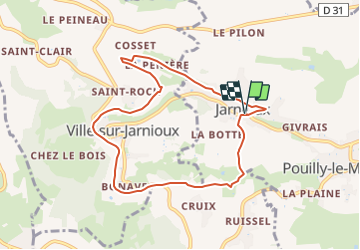
Trail On foot of 8.2 km to be discovered at Auvergne-Rhône-Alpes, Rhône, Porte des Pierres Dorées. This trail is proposed by AndreLACOMBE.
Description
À Jarnioux, parking du covoiturage après l'école. Après la Pénière, quitter la route sur la gauche pour continuer dans le circuit des Cadoles (flèche au départ mais mal indiqué par la suite) ; à voir. Après avoir retrouvé la route, poursuivre à gauche jusqu'à Ville-sur-Jarnioux ; Possibilité de pique-nique près du lavoir. Au poteau "Les Rues", rejoindre directement Jarnioux. Une variante peut nous emmener à Theizé - Château de Rochebonne - et retour à Jarnioux par Pouilly-le-Monial ; ce qui fait un total d'environ 15 km.
Positioning
Comments